")


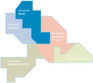
The municipality of Aland and its districts
The municipality is located in the Aland-Elbe-Niederung landscape conservation area. Grassland, woodland and water areas make up the largest part of the total area. The water-rich lowland area between the Elbe and Aland rivers is particularly inviting for long bike rides. The districts of Aulosen, Krüden, Pollitz, Scharpenhufe, Vielbaum, Wahrenberg and Wanzer belong to the municipality of Aland.
The municipality of Aland currently has 1,345 inhabitants. The total area is approx. 92.3 km².
Districts
Auloses

Aulosen is one of the northernmost districts of the Stendal administrative district and is located directly on the L 2 country road, which leads from Seehausen to Arendsee and is connected to the road network to the Lower Saxony municipalities of Schnackenburg, Lüchow and Dannenberg at Bömenzien. Aulosen has an idyllic lake with a natural park.
Bends

Krüden stretches for several kilometers. The town of Seehausen (Altmark) is around 5 km away. The river Aland flows to the north and east of the village. The castle pond with the Augraben lies on the edge of the village. The former castle was used as a school after 1950 and is now home to a tea factory and coffee roasting plant.
Pollitz
Pollitz is located in the far north of Saxony-Anhalt on the Aland river. Footpaths and cycle paths lead through the charming landscape, offering those seeking relaxation the opportunity to unwind in natural surroundings. There is a local fishing club.
Coulter hooves
Today's district of Scharpenhufe consists of Scharpenhufe and the smaller settlement of Nattewisch, which lies just under a kilometer east of Scharpenhufe. State Road 2 runs through the town.
Vielbaum
The settlements of Wilhelminenhof and Voßhof belong to Vielbaum. The village is located on the state road 2 and has a direct connection to the federal road 189. From here it is only about 3 kilometers to the Hanseatic town of Seehausen (Altmark) and the town of Wittenberge in neighboring Brandenburg can also be reached in a few minutes.
Wahrenberg

Wahrenberg is situated between the Elbe and Aland rivers. Some of the houses and farms were built on artificial mounds (elevations) to counter the threat of flooding. People had to 'protect' themselves from the floods, hence the name Wahrenberg. The diverse nature with its flora and fauna is a popular hunting and fishing ground. Wahrenberg is a particularly stork-rich village with over 20 stork nests, which have good breeding success every year due to the optimal food supply in the immediate vicinity
Wanzer

Wanzer is strongly characterized by its location in the lowlands of the Elbe and Aland rivers. It is particularly characteristic of Wanzer that half of the houses are located on or directly next to the Aland dyke. Over many generations, a dyke system has been created here, which enables a relatively safe life in the Elbe floodplain. The popular Elbe Cycle Path and the Aland Circuit, a cycle path that accompanies the biosphere reserve, run through Wanzer. The village church and the Bock windmill are two of the village's listed buildings.